Drones, Homes & Flood Damage: A&M-Galveston Researchers Map Ground Elevations from the Sky
December 12, 2019
Tweet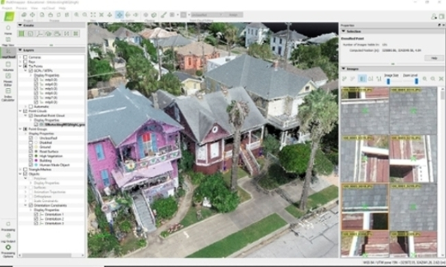
By Andréa Bolt
Diaz, a masters student and graduate resource assistant in the Marine Resource Management program at Texas A&M University at Galveston, has been assisting with research figuring first floor elevations within Galveston neighborhoods using drone-collected data.
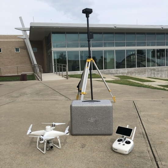
As part of Dr. Wes Highfield’s project developing accurate first floor mapping and flood risk data, Diaz has taken a DJI Phantom 4 RTK drone and installed sophisticated software that can produce 3-D renderings of structures, including ground elevation measurements.
Highfield, an associate professor in the Department of Marine Sciences, says first floor elevations (FFEs) measure how high a home is off the ground and the elevation of the structure, itself. FFEs are crucial to understanding and mitigating flood risk when an area is threatened with a storm surge or flooding. The problem is many structures not required to have an elevation measurement.
“This is an optional thing, this is not existing data. We can’t go to the city and request elevation certificates so we can make better models of flood damage - people are not required to have one. The homeowner can choose to have one, they can have a surveyor come out and shoot a line, but this is so much more efficient,” explained Highfield.
Highfield says metrics like these are known as stage-damage curves, metrics used by agencies like the Federal Emergency Management Agency (FEMA) and the Army Corps of Engineers to determine the percentage of value damaged.
The crux of the issue was finding a way to speed up how these measurements are determined in order to then hopefully approach city and state officials with this information to grow knowledge and drive change. With his drone, Diaz is able to “fly” an area with 400 homes in 20 minutes. He said it then only takes a few days to process and extract that data.
“Why do we care about damage?” Highfield asks. “Knowing how much damage a storm may cause before it happens can drive behaviors. Including preparedness, maybe some policy repercussions. We can determine if a structure needs to be raised or mitigated, elevated to reduce its risk. This little piece, it seems small in the grand scheme, but it’s really important for us. It also drives insurance rates, which is very important.”
Highfield said Galveston happens to be a perfect guinea pig to test this method of gathering data and the potential implications of this project.
Due to its history and housing diversity, the island is home to structures dating from the 1800s to the present. Homes built in the 1950s, 60s and 70s are largely slab on grade. The majority of beachfront homes are built on stilts.
“Some of these, the FFE is almost exactly the same as ground. Whereas you go to the beachfront house and you might have a 16-foot differential between the ground and the front door. You go from slab on grade to 20 feet off the ground. So being able to say when water enters a home drives that simplistic estimate of how much damage you can anticipate,” he explained.
Highfield and Diaz have recently started working with Galveston Island Coastal Resource Manager Dustin Henry. Henry provided them 70 elevation certificates and Diaz has just sent back his catalog of data to see how accurate the drone versus surveyor process is in practice. Henry has to filter the information due to personal data, and Diaz expects conclusive results in a few months.
For Highfield, the conclusion will be two-pronged. Firstly, this information will be utilized in outreach and risk communication.
“The second takeaway is what I would call applied research and the overlap between it, flood mitigation and damage estimation so we can make better models of predicting damage under certain scenarios. Right now we’re really shooting in the dark because of the assumptions we have to make around FFEs. This project and process could change that.”
The best case scenario will have Texas modeling an East Coast example.
In the United States, there is currently only one state that has all of its residential FFEs mapped and recorded: North Carolina. Residents can publicly access these numbers. If there’s a prediction of a water-related disaster event and an estimated depth of water is provided, they then have the ability to estimate the amount of water that could potentially enter the home. It’s a huge advantage in risk management, said Highfield.
“I imagine having this information publicly available at a parcel level. Say we have a Category 4 hurricane coming, the estimated surge is 12.5-feet. We can then say, ‘Here is a map of all the FFEs, here’s the differential between the first floor and 12.5-feet. These are the structures that are going to have water in them, these are the ones that aren’t.’ From a city, county and state preparedness level, that’s really important. For an emergency response, it’s crucial. Big picture aspect, that’s how I see this working.”
###
Media contact:Marketing and Communications
a_bolt@tamug.edu
409.740.4929
More:
Read more about Health & Environment
Read more about Science & Technology
Read more about Marine Sciences